|
AHMS is a ground-based height keeping performance monitoring system that utilises geometric height data
available from automatic dependant surveillance - broadcast (ADS-B) equipped aircraft in order to calculate the Altimetry System Error (ASE). Operators wishing to utilise the system are only required to hold an RVSM approval and be equipped with an ADS-B that sources geometric data provided by GNSS. Monitoring in airspace where a wide-area ADS-B network is available will not require an aircraft to specifically overfly any specific AHMS site as normal flight operations can be monitored on a continuous basis with no operational impact.
Like other ground-based systems, AHMS provides large volumes of data and permit repeated measurements on individual airframes, which helps RMA better assess the height keeping performance of airframes over time and discover undesirable trends and patterns.
For operators who wish to obtain our AHMS monitoring results, please visit HKP Monitoring Systems page.
History
In early 2011 the AAMA, operated by Airservices Australia, obtained ICAO endorsement of a methodology for height-keeping monitoring that utilises geometric height data available from ADS-B equipped aircraft. This followed a period of collaborative research with the US FAA as described in a series of ICAO papers which demonstrated the feasibility of the method.
After the endorsement, MAAR started collecting ADS-B data from an ADS-B station, located at the Aeronautical Radio of Thailand (AEROTHAI) headquarters in Bangkok, Thailand. The first usable set of data started from 10 November 2011. With the assistance from the FAA Technical Center and the AAMA, MAAR started providing ADS-B Height Monitoring Service in October 2012.
Current Service Area
There are currently 2 areas where MAAR's AHMS obtains data from:
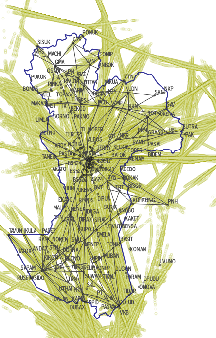
1. Coverage of ADS-B stations located in Thailand. The following picture shows the tracks of ADS-B-out aircraft observed by AEROTHAI's current ADS-B stations.
Note: The significant points and route-network information is for approximate reference only, and may not reflect the most up-to-date version.
2. Taipei FIR. As of August 2013, MAAR's AHMS also started processing ADS-B data from Taipei FIR. The coverage area covers the whole Taipei FIR.
Important Notes
- Only ADS-B equipped airframes operating in RVSM flight levels over coverage area of an ADS-B ground receiver can be monitored by the system.
- The system uses the geometric height information from the aircraft's GPS receiver as an input to calculate ASE.
- Geometric height from the aircraft's GPS receiver can be transmitted as either height above mean sea level (HAMSL) or height above ellipsoid (HAE); statistical analysis has to be performed to identify the correct height reference.
- Combining data from regions with different geoid helps determining the correct height reference.
- The system is cost-effective; no major additional investment is required if ADS-B receivers have already been installed for surveillance purposes.
- As an RMA, MAAR provides this service without any charges to operators.
|